Beneath the layers of time various manifestations of Carthage can be found. The first Carthage, founded by the Phoenician princess Elyssa-Dido, brought Africa to the forefront of history. The Punic Carthage of Hannon was queen of the seas and Hannibal's Carthage ruled the world during its shining hour of glory before it, too, vanished.
Augustus built Roman Carthage as the capital of Proconsular African and the Imperial Carthage which followed was a centre for the arts and learning. The Christian city of St Augustine was as famed for religion as for its other interests. For a century the city was held by the Vandals and then became Byzantine under Belisarius.
Carthage was finally conquered by the Arabs who then abandoned it in favour of Tunis. However, it remained a watchful outpost of the new capital city.
Throughout the centuries this extinct city has been inexorably pillaged as a source of building materials for Tunis and other Mediterranean towns. It has gradually been transformed into an agricultural centre famed for the quality of its produce.
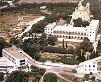
The installation of the French Protectorate over the Tunisian Regency enabled the Catholic Church to restore the splendid bisphoric of Saint Cyprien. The massive Basilica rising from the summit of Mount Bysra, known as the hill of Saint Louis, is evidence of this era which has disappeared since the country's independent status.
Aware of the importance of this legacy, modern Tunisia has resisted the temptation to watch Carthage disappear forever beneath a housing estate. Not all of the site has been built on, and a large archaeological zone is being set aside and protected as a national park.
The Carthage which has endured throughout history has always been sited on a peninsula which advances from the African continent into the Mediterranean basin. Each city was located fronting the shoreline, then expanded towards the hills in the hinterland. They are united, complete and superimposed on each other, of the ancient Carthage and the modern city echoing with the splendors and tribulations of its glorious 3000-year history.
The Wide-Angle View
One need only climb to the summit of Mount Byrsa to have an ideal point for observation and for conjuring up the drama of such a long history. From this point the visitor is able to contemplate a vast panorama and on foot can explore the remains of these civilizations, including a Punic quarter beneath the remain of a Roman forum, a Christian basilica and, in the premises of a former seminary, the museum where archaeological relics unearthed from excavations in the ruins a century ago are preserved and exhibited.
First of all, let's look at the horizon from the panoramic viewing point on the terrace. To the south-east in the distance a high range of mountains can be seen, against the horizon, with Tunis on one of the slopes. The suburbs of Tunis stretch as far as la Behira, an enormous salt lake which laps the shores of the Carthaginian peninsula.
Beyond it lies the la Soukra plain, an area of gardens and greenery close to the airport.
On the other side of la Behira, to the left, on a long, narrow strip of land is the La Goulette development, the foremost port in Tunisia. The Sidi Bou Said promontory dominates the entrance to the port, while the port of La Goulette itself is situated at the end with, in the background, the Boukornine mountain. The history of Tunisia has been made along these shores for three thousand years - Phoenicians, Punics, Romans, Vandals, Byzantines, Arabs and Muslims, Crusaders, Spaniards, Turks and French like so many waves breaking on the shore throughout the never-ending cycle of the years.
The Carthage Area
From the summit of Mount Byrsa, you can look along the peninsula horizon to the La Goulette conurbation; Le Kram is followed by the Salammbo district, where the two ancient harbours lie opposite each other, surrounded by trees and buildings. Further to the right is the old village of Douar Chott, built around simple ancient mosque.
Further to the right, an enormous archaeological site dotted with monuments including the circus and amphitheatre can be seen.
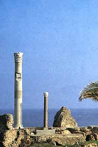
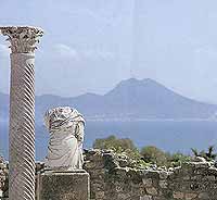
To the left, from the eastern slope of the hill as far as the shore is the residential district of Dermech. At the center of this suburb composed of gardens and villas some plots of land have been left undeveloped, and recent excavations have revealed several groups of remains such as those of a basilica and its precincts at the foot of the hill, and a Punic quarter at the edge of the sea. Further north, along the coast, are the remains of the Antonine thermal baths, which were among the most imposing in the whole Roman Empire. A large granite column which has been re-erected gives an idea of the height of the whole structure.
Several centuries of neglect have not succeeded in lessening the impact of its former splendour. From the baths, the coastline rises and becomes steeper, culminating in the majestic Cap Carthage - Sidi Bou Said. The presidential palace is now located on the southern slope of Borj Jedid hill, which overlooks the thermal baths.
At the top of the hill are the large water tanks which fed the baths. Further on, dominating the red ravine at Amilcar is the Basilica of Saint Cyprien. Halfway down this ravine can be found other large reservoirs which dammed up a spring at Dar Samiet, whilst the white village of Sidi Bou Said is sited high on the promontory.
Facing Byrsa's twin hill of mount Junon to the west is the Odeon plateau. The theatre covers the southern slope and the Odeon crowns the summit. An entire settlement of Roman villas, some partly excavated, covers this area. The most notable of these villas, called the 'villa de la Volière', is well worth a visit for the manner in which the buildings are positioned around the courtyard colonnade, and the terrace which has a marvellous view out over the Gulf and peninsula. Below the plateau to the north-west, in the fold of a valley surrounded by fields, are the traces of the largest Christian Basilica Majorum are found at the summit of a small hill. Finally the massive Maalga tanks are located on a small rise further to the left, where visitors travelling from Tunis by the main road reach the site. The tanks were fed by the Zaghouan aqueduct, some 70 km away as the crow flies.
From this point the Marsa plain stretches into the distance. The famous novel Slalmmbo by Gustave Flaubert starts with the following description:"It was at Megara, a suburb of Carthage, in the Amilcar gardens..."
Guide to main places of Interest and Monuments in Cartage
Mount Byrsa and the Museum
Mount Byrsa was the Acropolis of Punic
EGYPT - SYRIA - JORDAN