The Syrian Coast:
The
Syrian
Coast
consists
of
long
stretches
of
beaches
and
green
mountains.
These
mountains
are
mostly
covered
with
pine
and
oak
trees,
and
their
slopes
touch
the
shore.
This
landscape
repeats
itself
from
Ras
al-Basit
in
the
north
to
Tartus
in
the
south.
On
the
mountains
are
scattered
villages
and
towns
with
sources
of
mineral
water,
fresh
air
and
lovely
sceneries,
in
addition
to
many
archaeological
sites
&
famous
old
castles.
It
is
difficult
to
find
such
a
small
area
that
has
a
combination
of
fascinating
nature
&
great
monuments
where
history
left
its
imprints
on
every
corner
&
where
great
civilization
enriched
mankind's
knowledge
&
illuminated
his
way
to
prosperity.
Words
fail
to
describe
those
high
mountains
covered
with
evergreen
trees,
those
silvery
fresh
-
water
springs
surrounded
with
roses,
lilies,
narcissus,
daisies
and
various
blooming
wild
flowers
or
those
monuments
narrating
the
glory
of
the
past.
The
many
scattered
uncovered
relics
as
well
as
the
still
covered
ones
attracted
researchers
who
eagerly
long
to
investigate
about
the
ancient
peoples
&
their
deep
rooted
civilizations
from
allover
the
world
and
motivated
them
to
write
tomes
&
tomes
about
this
rich
heritage.
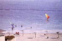
The Beaches:
The
Syrian
seashore
is
about
175
kms
long
and
its
numerous
beaches
are
distinguished
by
soft
sand,
unpolluted
sea,
moderate
climate,
clear
blue
sky
and
well
equipped
tourist
establishments.
Only
a
half
an
hour
drive
will
lead
you
to
one
of
the
many
mountains
summer
resorts
where
you
can
enjoy
the
cool
weather.
The
Mouhafazat
of
Latakia
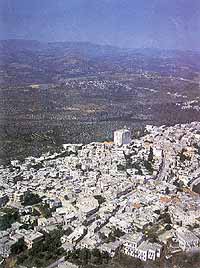
Latakia:
Latakia
is
Syris's
main
sea-port
on
the
Mediterranean
(186
kms
southwest
of
Aleppo).
348
kms
north
of
Damascus.
It
has
retained
its
importance
since
ancient
times.
Latakia
was
one
of
the
five
cities
built
by
Saluqoss
Nikator
in
the
2nd
century
B.C.
He
named
it
after
his
mother,
Laudetia.
Not
many
ancient
remains
have
survived
in
Latakia,
but
here
are
four
columns
and
a
Roman
arch
from
the
time
of
Septimus
Ottoman
construction
called
'Khan
al-Dukhan',
which
is
now
a
museum.
Latakia
is
the
sea-gate
to
Syria.
It
is
well-provided
with
accommodation,
and
is
well-placed
as
a
base
from
which
to
explore
the
coastal
regions
of
the
country.
Latakia
is
connected
to
other
main
cities
in
the
country
by
a
network
of
highways
and
asphalted
roads,
and
can
easily
be
reached
by
public
transport.
Hotels,
restaurants
and
chalets
of
different
standards
meet
every
taste.
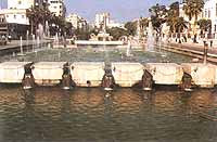
The
tourist
information
center,
at
the
entrance
of
the
city,
provides
tourists
with
necessary
information.
Latakia
"Mahabba
Festival"
which
takes
place
from
the
second
till
the
twelfth
of
August.
This
cultural,
sportive
&
artistic
event
attracts
many
arab
&
foreign
tourists.
Summer resorts and historical spots in the Mouhafazat of Latakia
There are beaches, mountains, archaeological sites and many relics of the Crusaders, all within a few hours from each other.
Ras Shamra (Ugarit)
16
kms
to
the
north
of
Latakia.
It
is
the
site
of
Ugarit,
the
kingdom
that
had
a
golden
past
in
administration,
education,
diplomacy,
law,
religion
and
economics
between
the
16th
and
13th
centuries
B.C.
It
is
the
kingdom
that
gave
humanity
the
first
alphabet
in
the
world.
This
alphabet
is
still
preserved
on
a
clay
tablet
at
the
National
Museum
in
Damascus.
Documents,
statues
and
jewels
from
the
Ugarit
kingdom
are
also
on
display
at
the
Latakia,
Aleppo
and
Tartus
museums.
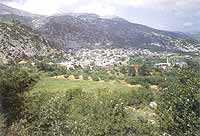
Al-Qardaha
Situated
30kms
from
Latakia,
it
is
a
small
town
located
14
kms
to
the
east
of
the
high-way
between
Jableh
&
Latakia
overlooking
a
beautiful
valley
surrounded
by
green
trees.
An
international
hotel
which
offers
good
services
is
available
there.
Jableh
It
is
another
Syrian
seaside
town,
28
kms
to
the
south
of
Latakia.
It
has
a
theatre
built
to
accommodate
7,000
to
8,000
spectators.
Slenfeh
50 kms east of Latakia and 1200 ms above sea-level. It has a spectacular scenery and lovely weather.
Kasab
65 kms north the Latakia, located on the Aqra' mountain amongst woods and thickets, 800 ms above sea-level. The road leading to it from Latakia is one of the most beautiful in Syria. It runs through woods and meadows of wild flowers and groves of olive and pine, orchards of apple trees leading to the beautiful forest of Frulloq.
Salma
Situated 12 kms from Slenfeh and 800 ms above sea-level. It is characterized by moderate climate and pure mineral water.
Ras al-Bassit
Located on the northern part of the Syrian shore, about 40 kms to the north of Latakia, it is one of the most beautiful spots on the Mediterranean: a wide bay, with clear water and clean sand, Surrounded by mountains and green hills. Chalets, camping sites and restaurants along the shore make Ras Al-Bassit all the most attractive to visitors.
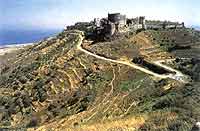
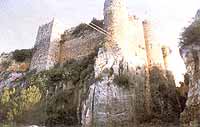
Salah al-Din Citadel
Due
to
the
importance
of
its
position,
this
castle
has
been
exploited
before
the
crusaders,
nevertheless
it
was
described
as
the
most
impregnable
crusader
fortress.
It
stands
on
a
rocky
spur
whose
vertical
walls
rise
above
the
junction
of
two
fast
flowing
streams.
It
was
completely
isolated
from
the
plateau
by
a
deep
ditch
dug
right
through
the
connection
neck
of
land.
Today
there
is
a
drawbridge
and
a
road
which
provide
easy
access
to
the
foot
of
this
"eagle's
nest".
View from Latakia
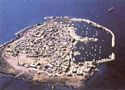
Arwad
Island
Al-Marqab
Citadel
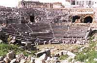
Jableh
Theatre
Safita
Syrian
Coast
Salah-al
Din
Citadel
Amrit
-
Tartus
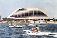
Meridien
Hotel
-
Latakia

Côte
d'Azur
resort
-
Latakia
Kasab
Palace
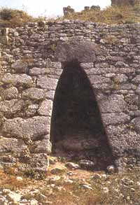
Gate
from
Ugarit
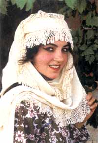
Popular
Costume
from
Latakia
The Mouhafazat of Tartus
Tartus
The
second
most
important
Syrian
seaport
on
the
Mediterranean
(90
kms
to
the
south
of
Latakia).
It
was
called
Antaradus
by
the
Phoenicians
and
Tortusa
by
the
Byzantines.
Tortusa
was
to
become
one
of
the
main
supply
ports
for
the
Crusaders
and
a
military
base
of
considerable
importance.
It
was
held
by
the
Templars,
but
recovered
by
Saladin
in
1188.
The
arches,
wall
-
towers
and
narrow
lanes
in
Tartus
evoke
what
the
town
must
have
been
like
in
medieval
times.
A
jewel
of
Romanesque
art
is
the
cathedral
of
Tartus,
which
is
now
a
museum
containing
relics
from
various
Syrian
civilizations.
During
summer
an
attractive
festival
is
held
there
containing
many
activities
such
as
sea
sports,
handicrafts
exhibition,
shopping
center
&
cultural
events.
Summer resorts and historical spots in the Mouhafazat of Tartus
Arwad
This
is
the
only
island
in
Syria,
and
it
is
located
3
kms
from
Tartus.
It
was
an
independant
kingdom
named
Aradus
in
the
days
of
the
Canaanites.
It
was
often
mentioned
in
inscriptions
because
of
its
importance
in
commerce
and
seafaring.
Arwad
is
a
beautiful
small
island,
with
a
mass
of
houses
and
fortresses
with
narrow
lanes.
It
has
many
cafés
and
restaurants
overlooking
Tartus
and
the
sea.
Its
ancient
citadel
was
used
as
a
prison
for
the
nationalists
during
the
resistance
against
the
French.
The
walls
of
some
cells
in
this
citadel
are
still
covered
with
the
writings
of
the
nationalists.
Draykish
A lovely town, 29 kms from Tartus, situated on a mountain covered with olive trees which overlook the sea. It has a reputation for its well-known mineral water. It has several hotels and camping sites.
Safita
10
kms
south
of
Draykish,
35
kms
east
of
Tartus
and
380
ms
above
sea
-
level,
Safita
is
surrounded
by
hills
covered
with
olive
trees
and
flowers
on
all
sides.
The
present
-
day
town
with
its
tiles
roofs
stands
on
the
site
of
the
fortress
that
was
called
Castle
le
Blanc
by
the
crusaders.
One
of
its
huge
towers,
about
38
ms
high
is
still
standing;
this
tower
contains
a
chapel,
which
has
never
been
deconsecrated:
Christians
still
hold
their
services
in
it.
Hosn Sleiman
25 kms from Safita; 14 kms beyond Draykish, in the direction of Misyaf, "Hosn Sleiman" is the Arabic name for the site of ancient Baetocece; it was here, in the heart of these wild mountains cut through by ravines, that the inhabitants of Aradus (the present Isle of Arwad) once built a temple dedicated to Baal and Astrate.
Arima
Today Qal'aat al-Arima (15 kms southwest of Safita), once a forward strong point for castle le Blanc and for the Crac, it still has two towers dating back to the 12th and 13th centuries.
Qala'at Yahmur
(Chastel Ronger or Castrum Rubrum), 20 kms west of safita on the Tartus road. Like Arima, Qal'aat Yahmur was a small fortress, and its 15 ms high keep is still impressive.
Mashta al-Helu
Located
north-east
of
Safita,
it
is
the
largest
in
a
group
of
small
villages
scattered
on
the
green
hills,
where
the
weather
is
cool
even
on
the
hottest
summer
days.
The
most
attractive
among
these
white
stone
villages
is
al-Kafroon
(3kms
from
Mashta
al-Helu).
It
is
located
at
the
foot
of
a
small
hill,
completely
covered
with
oak
trees
and
surrounded
by
mountains
with
many
churches
and
mosques.
Also
worth
visiting
is
Mar
Elias,
a
cave-like
church
in
the
north
of
the
village.
An
international
hotel
resort,
in
addition
to
many
hotels,
restaurants
&
cafés
are
available
in
the
apple
orchards
along
the
streams
that
run
through
it.
Banyas
This city is located on the Syrian coast, 55 kms to the south of Latakia. It was an ancient Phoenician seaport. Today it is better known for its oil refinery.
Al-Marqab Citadel
This
citadel
is
only
6
kms
south-east
of
Banyas,
and
is
500
ms
above
sea-level.
It
is
enormous:
there
are
not
less
than
fourteen
square
and
round
towers
jutting
from
the
curtain
wall
that
encircles
the
hilltop
to
from
a
triangular
bastion.
Its
southern
corner,
sharper
than
the
others
and
bristling
with
defences,
has
a
keep
rising
above
it
like
the
prow
of
a
ship.
What
makes
it
particularly
glowering
is
the
black
basalt
stone
with
which
it
was
built.
There
are
beautiful
gardens
and
orchards
surrounding
it
and
the
sea
is
not
far
away.
This
citadel
could
accommodate
1000
people,
in
addition
to
the
garrison,
along
with
provisions
to
last
them
for
five
years.
Amrit
It
is
located
to
the
south
of
Tartus.
It
contains
a
unique
temple
dating
back
to
the
5th
century
B.C.
This
temple
is
carved
in
rock
and
surrounded
by
water.
Amrit
also
contains
the
remains
of
a
big
stadium
which
could
seat
11
thousand
spectators,
and
dates
back
to
the
16th
century
B.C.
The
ancient
Syrians
used
the
stadium
for
their
sport
seasons,
a
practice
which
was
picked
up
by
the
Greeks
after
8
centuries,
and
was
called
the
Olympic
games.
(ALEPPO - DAMASCUS - LATAKIA - PALMYRA - HOMS - HAMA)
(BOSRA - BANYAS - TARTUS - ZABADANI)
EGYPT - LEBANON - JORDAN